

Jay and Valerie
Travel Information
Flying:
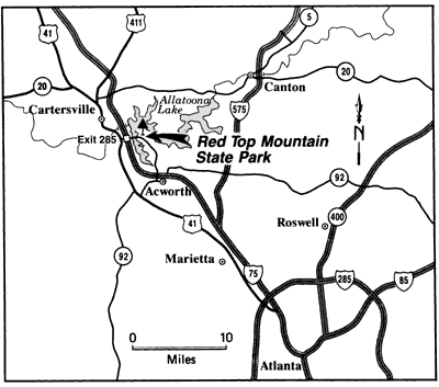
Atlanta's Hartsfield-Jackson International Airport (ATL) is the closest airport. Delta is hubbed out of Atlanta, and often has the best rates. You will want to rent a car at the airport for traveling to Cartersville. From the airport, follow the signs for I-85 North. I-85 will merge with I-75. Stay on I-75 North and follow the directions below.Driving:

Take I-75 north to Exit 285 (Red Top Mountain Road), about 25 miles north of the northern side of I-285. At the end of the exit ramp, turn right and follow this road across a large bridge and into Red Top Mountain State Park. If you're staying in the cottages or lodge, proceed to the lodge for check-in. If you'll be camping or in an RV, proceed to the visitors center during normal business hours.

Atlanta Gotchas:
Atlanta has two main interstates, I-75 and I-85 running through it. These interstates run together for about 10 miles through downtown which can make the exit number scheme confusing. The city is surrounded by I-285, also called The Perimeter.Atlanta traffic is extremely bad. We highly, highly, HIGHLY recommend you avoid driving during rush hour (about 4-7pm on Fridays).